

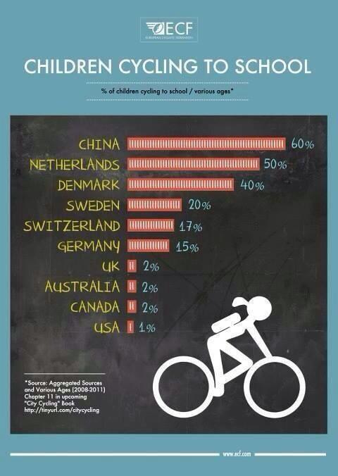
A recent flurry of twitter discussion on the very low level of cycling to school in Britain, and how poorly this country compares to more cycling-friendly places, prompted me to look for school level data on how children travel to school.
In the map below is every school in England, with data on mode of travel to school from the School Census 2011. The red dots denote schools where less than 2 per cent of children cycle, the purple dots where 2-5% cycle, the blue dots where 5-10% cycle and the green dots where more than 10% cycle.
Why 2011? It’s the most recent data there is since the government stopped collecting this data. It defies belief that with a growing epidemic of childhood obesity, and evidence that fewer kids are walking or cycling to school, the government should respond by pushing its head further into the sand.
Here’s a map of just the schools where more than 10% of children cycle to school:
The top schools in terms of cycling to school? Step forward the Parkside Federation Academies in Cambridge, who reported more than 60% cycling to school.
The schools with least car-dependent pupils were Sarah Bonnell School in Newham and Capital City Academy in Brent, both reporting less than 0.3% of children travelling to school by car. The most car-bound schools are Adlington Primary School in Cheshire, Windlestone School in County Durham and Pannal Primary School in North Yorkshire, which reported a full 99% of children travel to school by car.
Finally, here’s a map showing all schools reporting more than 80% of children get to school by car:
The raw data is available on a Google Fusion Table. I merged the census data with a different dataset containing school addresses, and geocoded that using Google’s geocode service. A few caveats:
1. The School Census on travel to school mode is conducted by a show of hands in assembly. So must be taken with some caution.
2. Some schools did not report cycling figures, all that appears in the data is an ‘x’.
3. Some schools on the map didn’t report any data at all. I think these are mostly independent schools, perhaps they are exempt from the reporting requirements.
4. It’s possible that Google’s geocode process has not processed all the schools, this may take a few more hours/days.
While the low levels of cycling to school is depressing, most primary school children and a large minority of secondary school children still walk to school, a healthy and sociable option, though it does seem walking to school rates are gradually declining in favour of the motorised ‘school run’.
The same data (and more) is presented in a less rough-and-ready way by the School Travel Health Check website.
Thanks to Richard Evans for pointing out that this data exists. And Tejvan Pettinger for the photo.